
Phetchaburi Province topographic map
Interactive map
Click on the map to display elevation.
About this map
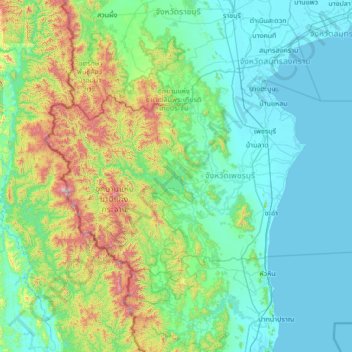
Name: Phetchaburi Province topographic map, elevation, terrain.
Location: Phetchaburi Province, Thailand (12.39620 99.09942 13.33333 100.45833)
Average elevation: 227 m
Minimum elevation: -1 m
Maximum elevation: 1,458 m
Other topographic maps
Click on a map to view its topography, its elevation and its terrain.
Kaeng Krachan
Thailand > Phetchaburi Province > Kaeng Krachan
Kaeng Krachan, Phetchaburi Province, Thailand
Average elevation: 95 m