
Johor topographic map
Interactive map
Click on the map to display elevation.
About this map
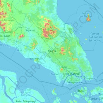
Name: Johor topographic map, elevation, terrain.
Location: Johor, Malaysia (1.19550 102.34749 2.83205 104.75069)
Average elevation: 27 m
Minimum elevation: -2 m
Maximum elevation: 1,133 m
Other topographic maps
Click on a map to view its topography, its elevation and its terrain.
Johor Bahru
Johor Bahru, Iskandar Malaysia, Johor, 80350, Malaysia
Average elevation: 28 m
Pulai
Malaysia > Johor > Iskandar Puteri
Pulai, Iskandar Puteri, Johor Bahru, Iskandar Malaysia, Johor, 79100, Malaysia
Average elevation: 25 m
Iskandar Puteri
Iskandar Puteri, Johor Bahru, Iskandar Malaysia, Johor, Malaysia
Average elevation: 26 m