
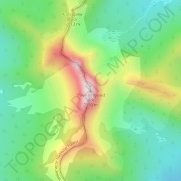
Three Fingered Jack topographic map
Interactive map
Click on the map to display elevation.
About this map
Name: Three Fingered Jack topographic map, elevation, terrain.
Location: Three Fingered Jack, Linn County, Oregon, USA (44.47897 -121.84311 44.47907 -121.84301)
Average elevation: 1,881 m
Minimum elevation: 1,647 m
Maximum elevation: 2,286 m
Other topographic maps
Click on a map to view its topography, its elevation and its terrain.
Waldo Glacier
Waldo Glacier, Pacific Crest Trail, Jefferson County, Oregon, USA
Average elevation: 2,352 m
Thayer Glacier
Thayer Glacier, climber's trail, Deschutes County, Oregon, USA
Average elevation: 2,423 m
Eugene Glacier
Eugene Glacier, South Sister Climber Trail #36, Deschutes County, Oregon, USA
Average elevation: 2,487 m
Coe Glacier
Coe Glacier, Barrett Spur, Hood River County, Oregon, USA
Average elevation: 2,328 m
Renfrew Glacier
Renfrew Glacier, climber's trail, Deschutes County, Oregon, USA
Average elevation: 2,538 m
Hayden Glacier
Hayden Glacier, climber's trail, Deschutes County, Oregon, USA
Average elevation: 2,542 m
Wallowa Mountains
Wallowa Mountains, Wallowa County, Oregon, USA
Average elevation: 2,475 m
Diller Glacier
Diller Glacier, climber's trail, Deschutes County, Oregon, USA
Average elevation: 2,416 m
Bend Glacier
Bend Glacier, Broken Top NW Ridge route, Deschutes County, Oregon, USA
Average elevation: 2,350 m
Collier Glacier
Collier Glacier, climber's trail, Deschutes County, Oregon, USA
Average elevation: 2,549 m
Prouty Glacier
Prouty Glacier, South Sister Climber Trail #36, Deschutes County, Oregon, USA
Average elevation: 2,589 m
Milk Creek Glacier
Milk Creek Glacier, Pacific Crest Trail, Jefferson County, Oregon, USA
Average elevation: 2,508 m
Lathrop Glacier
Lathrop Glacier, Mt. Thielsen climber's trail, Douglas County, Oregon, USA
Average elevation: 2,235 m
Newton Clark Glacier
Newton Clark Glacier, Cooper Spur Trail #600B, Hood River County, Oregon, USA
Average elevation: 2,589 m
Langille Glacier
Langille Glacier, Eliot west moraine, Hood River County, Oregon, USA
Average elevation: 2,165 m
Zigzag Glacier
Zigzag Glacier, Mountaineer Trail #798, Clackamas County, Oregon, USA
Average elevation: 2,620 m
Crook Glacier
Crook Glacier, Broken Top NW Ridge route, Deschutes County, Oregon, USA
Average elevation: 2,347 m
Reid Glacier
Reid Glacier, Yocum Ridge Trail #771, Clackamas County, Oregon, USA
Average elevation: 2,410 m
Eliot Glacier
Eliot Glacier, Eliot west moraine, Hood River County, Oregon, USA
Average elevation: 2,316 m
White River Glacier
White River Glacier, Mountaineer Trail #798, Clackamas County, Oregon, USA
Average elevation: 2,523 m
Mount Tabor
Mount Tabor, Portland, Multnomah County, Oregon, 97215, USA
Average elevation: 86 m
Lost Creek Glacier
Lost Creek Glacier, South Sister Climber Trail #36, Deschutes County, Oregon, USA
Average elevation: 2,430 m
Clark Glacier
Clark Glacier, South Sister Climber Trail #36, Deschutes County, Oregon, USA
Average elevation: 2,578 m
Skinner Glacier
Skinner Glacier, South Sister Climber Trail #36, Deschutes County, Oregon, USA
Average elevation: 2,480 m
Sandy Glacier
Sandy Glacier, Yocum Ridge Trail #771, Clackamas County, Oregon, USA
Average elevation: 2,365 m