
Thank you for supporting this site ❤️
Make a donation
Make a donation
Magsingal topographic map
Click on the map to display elevation.
Thank you for supporting this site ❤️
Make a donation
Make a donation
About this map
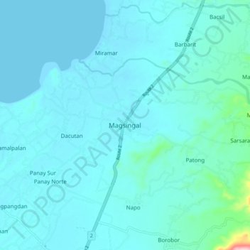
Name: Magsingal topographic map, elevation, terrain.
Location: Magsingal, Ilocos Sur, Ilocos Region, 2730, Philippines (17.64519 120.38573 17.72519 120.46573)
Average elevation: 18 m
Minimum elevation: 0 m
Maximum elevation: 214 m
Thank you for supporting this site ❤️
Make a donation
Make a donation
Other topographic maps
Click on a map to view its topography, its elevation and its terrain.
Vigan
Vigan is situated in a Quaternary Age sedimentary plain called the Vigan-Bantay Plain which is part of the Ilocos coastal plain. The Vigan-Bantay Plain is bounded on the east by a moderately rugged Miocene sediments consisting of interbedded sandstones and shale to very rugged Meta-volcanics and Meta sediment…
Average elevation: 34 m