
Karakelong Island topographic map
Interactive map
Click on the map to display elevation.
About this map
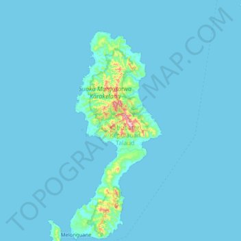
Name: Karakelong Island topographic map, elevation, terrain.
Location: Karakelong Island, Talaud Islands, North Sulawesi, Indonesia (3.98796 126.48119 4.62796 127.12119)
Average elevation: 19 m
Minimum elevation: 0 m
Maximum elevation: 637 m
Other topographic maps
Click on a map to view its topography, its elevation and its terrain.
Tutuyan
Indonesia > North Sulawesi > Tutuyan
Tutuyan, North Sulawesi, Indonesia
Average elevation: 49 m
Bangka Island
Indonesia > North Sulawesi > Bitung
Bangka Island, Bitung, North Sulawesi, Indonesia
Average elevation: 35 m
Talaud Islands
Talaud Islands, North Sulawesi, 95885, Indonesia
Average elevation: 8 m