
Napier City topographic map
Interactive map
Click on the map to display elevation.
About this map
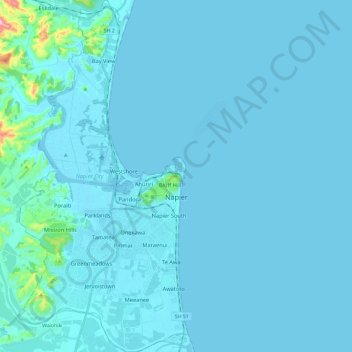
Name: Napier City topographic map, elevation, terrain.
Location: Napier City, Hawke's Bay, New Zealand (-39.57047 176.81127 -39.38819 176.92593)
Average elevation: 40 m
Minimum elevation: -3 m
Maximum elevation: 370 m
Other topographic maps
Click on a map to view its topography, its elevation and its terrain.
Mataka
New Zealand > Northland > Far North District > Bay of Islands-Whangaroa Community
Mataka, Bay of Islands-Whangaroa Community, Far North District, Northland, New Zealand
Average elevation: 45 m
Lyttelton
New Zealand > Canterbury > Lyttelton
Lyttelton, Christchurch City, Canterbury, 8082, New Zealand
Average elevation: 99 m
Whanganui
Whanganui, Whanganui District, Manawatu-Whanganui, 4500, New Zealand
Average elevation: 73 m
Queenstown
Queenstown, Queenstown-Lakes District, Otago, 9348, New Zealand
Average elevation: 596 m
Bluff Hill
Bluff Hill, Napier, Napier City, Hawke's Bay, 4001, New Zealand
Average elevation: 14 m
Anna Glacier
Anna Glacier, Mackenzie District, Canterbury, New Zealand
Average elevation: 2,446 m
Pickelhaube Glacier
Pickelhaube Glacier, Westland District, West Coast, New Zealand
Average elevation: 1,836 m
Rakiura National Park
Rakiura National Park, Southern Circuit Track, Southland, New Zealand
Average elevation: 63 m
Eugenie Glacier
New Zealand > Canterbury > Mount Cook Village
Eugenie Glacier, Hooker Valley Track, Mount Cook Village, Mackenzie District, Canterbury, 7946, New Zealand
Average elevation: 1,827 m
Selwyn District
Selwyn District, Canterbury, New Zealand
Average elevation: 679 m
Mount Tarawera
New Zealand > Bay of Plenty > Rotorua
Mount Tarawera, Rotorua, Rotorua District, Bay of Plenty, New Zealand
Average elevation: 894 m
Mount Ruapehu
Mount Ruapehu, Ruapehu District, Manawatu-Wanganui, New Zealand
Average elevation: 2,439 m
Mount Tongariro
Mount Tongariro, Ruapehu District, Manawatu-Wanganui, New Zealand
Average elevation: 1,675 m
Mount Tasman
Mount Tasman, Westland District, West Coast, New Zealand
Average elevation: 2,798 m
Cascade Glacier
Cascade Glacier, Mackenzie District, Canterbury, New Zealand
Average elevation: 2,106 m
Bell Glacier
Bell Glacier, poled route only, Queenstown-Lakes District, Otago, New Zealand
Average elevation: 1,666 m
Mount Hutt
Mount Hutt, Ashburton District, Canterbury, New Zealand
Average elevation: 1,732 m
Mount Vancouver
Mount Vancouver, Mackenzie District, Canterbury, New Zealand
Average elevation: 2,804 m
Mount Stewart
Mount Stewart, Manawatu District, Manawatu-Wanganui, New Zealand
Average elevation: 103 m
Te Hīwai / Murchison Glacier
Te Hīwai / Murchison Glacier, Mackenzie District, Canterbury, New Zealand
Average elevation: 1,875 m
Aida Glacier
Aida Glacier, Mackenzie District, Canterbury, New Zealand
Average elevation: 1,999 m
Mueller Glacier
New Zealand > Canterbury > Mount Cook Village
Mueller Glacier, Mueller Hut Route, Mount Cook Village, Mackenzie District, Canterbury, 7946, New Zealand
Average elevation: 1,616 m
Dennistoun Glacier
Dennistoun Glacier, Mackenzie District, Canterbury, New Zealand
Average elevation: 2,026 m
Maud Glacier
Maud Glacier, Mackenzie District, Canterbury, New Zealand
Average elevation: 1,711 m
Mount Taranaki
Mount Taranaki, Stratford District, Taranaki, 4642, New Zealand
Average elevation: 1,847 m
Mount Evans
Mount Evans, Southland District, Southland, New Zealand
Average elevation: 554 m
South Island
South Island, Ashburton District, Canterbury, New Zealand
Average elevation: 201 m
Baker Glacier
Baker Glacier, Westland District, West Coast, New Zealand
Average elevation: 1,929 m
Mount Dampier
Mount Dampier, Mackenzie District, Canterbury, New Zealand
Average elevation: 2,847 m
Tasman Glacier
Tasman Glacier, Caroline hut to ball hut, Mackenzie District, Canterbury, New Zealand
Average elevation: 1,781 m
Mount Ngāuruhoe
Mount Ngāuruhoe, Ruapehu District, Manawatu-Wanganui, New Zealand
Average elevation: 1,726 m
Ball Glacier
Ball Glacier, Caroline hut to ball hut, Mackenzie District, Canterbury, New Zealand
Average elevation: 1,324 m
Franz Josef
Franz Josef, Westland District, West Coast, 7856, New Zealand
Average elevation: 277 m
Tauranga City
Tauranga City, Bay of Plenty, New Zealand
Average elevation: 55 m
Bonar Glacier
Bonar Glacier, Westland District, West Coast, New Zealand
Average elevation: 1,916 m
Wellington City
Wellington City, Wellington, New Zealand
Average elevation: 80 m
Gisborne Point
New Zealand > Bay of Plenty > Rotoiti > Gisborne Point
Gisborne Point, Rotoiti, Rotorua District, Bay of Plenty, 3074, New Zealand
Average elevation: 350 m
Mount Aspiring
Mount Aspiring, Westland District, West Coast, New Zealand
Average elevation: 2,257 m
Cerberus
Cerberus, Queenstown-Lakes District, Otago, New Zealand
Average elevation: 1,819 m
Christchurch
New Zealand > Canterbury > Christchurch
Christchurch, Christchurch City, Canterbury, New Zealand
Average elevation: 41 m
Lower Volta Glacier
Lower Volta Glacier, Westland District, West Coast, New Zealand
Average elevation: 1,472 m
Napier
Napier, Napier City, Hawke's Bay, 4001, New Zealand
Average elevation: 33 m