
Svenskøya topographic map
Interactive map
Click on the map to display elevation.
About this map
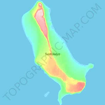
Name: Svenskøya topographic map, elevation, terrain.
Location: Svenskøya, Svalbard, Norway (78.63819 26.35740 78.83929 27.06980)
Average elevation: 16 m
Minimum elevation: -1 m
Maximum elevation: 278 m
Other topographic maps
Click on a map to view its topography, its elevation and its terrain.
Jan Mayen
Jan Mayen consists of two geographically distinct parts. Nord-Jan has a round shape and is dominated by the 2,277 m (7,470 ft) high Beerenberg volcano with its large ice cap (114.2 km2 or 44 sq mi), which can be divided into twenty individual outlet glaciers. The largest of those is Sørbreen, with an area of…
Average elevation: 23 m
Norway
Little has been found dating from the early Iron Age (the last 500 years BC). The dead were cremated, and their graves contain few burial goods. During the first four centuries AD, the people of Norway were in contact with Roman-occupied Gaul. About 70 Roman bronze cauldrons, often used as burial urns, have…
Average elevation: 294 m