
Aisne topographic map
Interactive map
Click on the map to display elevation.
About this map
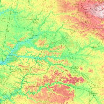
Name: Aisne topographic map, elevation, terrain.
Average elevation: 133 m
Minimum elevation: 27 m
Maximum elevation: 388 m
Other topographic maps
Click on a map to view its topography, its elevation and its terrain.
Givenchy-en-Gohelle
France > Nord-Pas-de-Calais and Picardy > Givenchy-en-Gohelle
Givenchy-en-Gohelle, Lens, Pas-de-Calais, Nord-Pas-de-Calais and Picardy, Metropolitan France, 62580, France
Average elevation: 89 m
La Motte
France > Nord-Pas-de-Calais and Picardy
La Motte, Avesnes-sur-Helpe, Nord, Nord-Pas-de-Calais and Picardy, Metropolitan France, 59288, France
Average elevation: 148 m
La Malmaison
France > Nord-Pas-de-Calais and Picardy > La Malmaison
La Malmaison, Laon, Aisne, Nord-Pas-de-Calais and Picardy, Metropolitan France, 02190, France
Average elevation: 105 m
Lille
France > Nord-Pas-de-Calais and Picardy
Lille, Nord, Nord-Pas-de-Calais and Picardy, Metropolitan France, France
Average elevation: 32 m
Ravenel
France > Nord-Pas-de-Calais and Picardy > Ravenel
Ravenel, Clermont, Oise, Nord-Pas-de-Calais and Picardy, Metropolitan France, 60130, France
Average elevation: 117 m