
Estavayer-le-Lac topographic map
Interactive map
Click on the map to display elevation.
Estavayer-le-Lac
The municipality is located in the Broye district, on the southern bank of Lake Neuchatel at an elevation of 430 to 460 meters (1,410 to 1,510 ft). It is a district capital and a regional administration and business center.
About this map
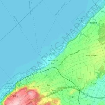
Name: Estavayer-le-Lac topographic map, elevation, terrain.
Average elevation: 455 m
Minimum elevation: 422 m
Maximum elevation: 611 m
Other topographic maps
Click on a map to view its topography, its elevation and its terrain.
Forel
Switzerland > Fribourg > District de la Broye > Estavayer > Vernay > Forel
Average elevation: 458 m