
Slope County topographic map
Interactive map
Click on the map to display elevation.
About this map
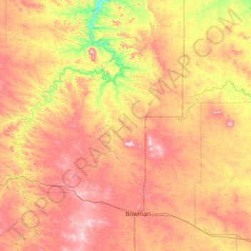
Name: Slope County topographic map, elevation, terrain.
Location: Slope County, North Dakota, United States (46.27931 -104.04610 46.63102 -102.92335)
Average elevation: 860 m
Minimum elevation: 699 m
Maximum elevation: 1,049 m
White Butte, the highest natural point in North Dakota at an elevation of 3506 ft (1062 m), is in southeast Slope County.