
Isabela topographic map
Interactive map
Click on the map to display elevation.
About this map
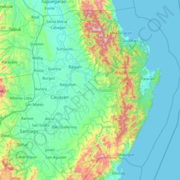
Name: Isabela topographic map, elevation, terrain.
Location: Isabela, Cagayan Valley, Philippines (16.39443 121.34806 17.56939 122.66926)
Average elevation: 226 m
Minimum elevation: -1 m
Maximum elevation: 1,760 m
The highest point of the province is located near the border with Cagayan. Mount Dos Cuernos peak has an elevation of 1,785 metres (5,856 ft) located in San Pablo near the border with Maconacon. Other notable peaks in the Northern Sierra Madre Natural Park is Mount Cresta in Divilacan with an elevation of 1,672 metres (5,486 ft).
Other topographic maps
Click on a map to view its topography, its elevation and its terrain.