
Álvaro Obregón topographic map
Interactive map
Click on the map to display elevation.
About this map
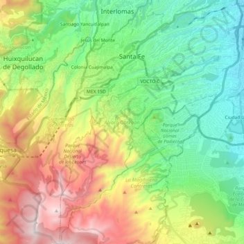
Name: Álvaro Obregón topographic map, elevation, terrain.
Location: Álvaro Obregón, Mexico City, Mexico (19.23261 -99.32436 19.40374 -99.17171)
Average elevation: 2,814 m
Minimum elevation: 2,259 m
Maximum elevation: 3,847 m
Other topographic maps
Click on a map to view its topography, its elevation and its terrain.
Gustavo A. Madero
Gustavo A. Madero, Mexico City, Mexico
Average elevation: 2,305 m