
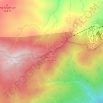
Mount Harrison topographic map
Interactive map
Click on the map to display elevation.
About this map
Name: Mount Harrison topographic map, elevation, terrain.
Location: Mount Harrison, Sevier County, Tennessee, USA (35.69691 -83.57273 35.69701 -83.57263)
Average elevation: 927 m
Minimum elevation: 541 m
Maximum elevation: 1,176 m
Other topographic maps
Click on a map to view its topography, its elevation and its terrain.
Murfreesboro
USA > Tennessee > Murfreesboro
Murfreesboro, Rutherford County, Tennessee, USA
Average elevation: 188 m
Great Smoky Mountains National Park
Great Smoky Mountains National Park, Little River Trail, Elkmont, Sevier County, Tennessee, USA
Average elevation: 765 m
Hill Country
USA > Tennessee > Hill Country
Hill Country, Sullivan County, Tennessee, 37621, USA
Average elevation: 548 m
Wellington Park
USA > Tennessee > Wellington Park
Wellington Park, Washington County, Tennessee, 37604, USA
Average elevation: 547 m
The Swamps
USA > Tennessee > Mount Denson
The Swamps, Hyde Road, Mount Denson, Robertson County, Tennessee, 37172, USA
Average elevation: 216 m