
Broward County topographic map
Interactive map
Click on the map to display elevation.
About this map
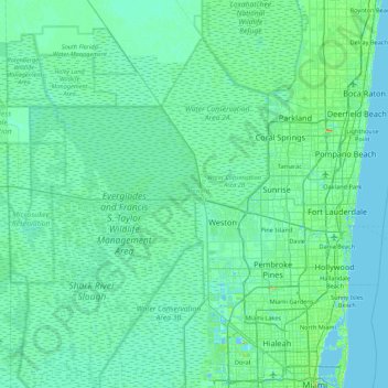
Name: Broward County topographic map, elevation, terrain.
Location: Broward County, Florida, USA (25.95675 -80.88139 26.35550 -80.01528)
Average elevation: 5 m
Minimum elevation: -1 m
Maximum elevation: 42 m
Other topographic maps
Click on a map to view its topography, its elevation and its terrain.
Lake Alice
USA > Florida > City of Gainesville Municipal Boundaries
Lake Alice, Museum Road, Daysville, City of Gainesville Municipal Boundaries, Alachua County, Florida, 32601, USA
Average elevation: 30 m
Dry Tortugas National Park
Dry Tortugas National Park, Monroe County, Florida, USA
Average elevation: 0 m
Deerfield Beach
USA > Florida > Deerfield Beach
Deerfield Beach, Broward County, Florida, USA
Average elevation: 5 m
Gainesville
USA > Florida > Gainesville
Gainesville, Alachua County, Florida, USA
Average elevation: 42 m
Dawson Island
USA > Florida > Jacksonville
Dawson Island, Jacksonville, Duval County, Florida, USA
Average elevation: 2 m
St. Augustine
USA > Florida > St. Augustine
St. Augustine, St. Johns County, Florida, 32084, USA
Average elevation: 5 m