
Thank you for supporting this site ❤️
Make a donation
Make a donation
Lake Albert topographic map
Click on the map to display elevation.
Thank you for supporting this site ❤️
Make a donation
Make a donation
Lake Albert
It is about 160 kilometres (99 mi) long and 30 kilometres (19 mi) across at its widest, with a maximum depth of 51 metres (167 ft), and a surface elevation of 619 metres (2,031 ft) above sea level.
Thank you for supporting this site ❤️
Make a donation
Make a donation
About this map
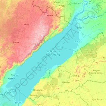
Name: Lake Albert topographic map, elevation, terrain.
Location: Lake Albert, Hoima, Western Region, Uganda (0.99817 30.35050 2.51412 31.53419)
Average elevation: 1,076 m
Minimum elevation: 607 m
Maximum elevation: 2,389 m
Thank you for supporting this site ❤️
Make a donation
Make a donation
Other topographic maps
Click on a map to view its topography, its elevation and its terrain.
Thank you for supporting this site ❤️
Make a donation
Make a donation