
Make a donation
Münstertal topographic map
Click on the map to display elevation.
Make a donation
Münstertal
The Münstertal stretches from Staufen im Breisgau up into the Black Forest. It divides into several side valleys and extends in the direction of Belchen(Schwarzwald), via the district of Stohren towards the Schauinsland and via the Münsterhalde towards Badenweiler. The altitude of the Münstertal ranges from 380 m above sea level up to 1414 m on the summit of the Belchen, which represents a difference of 1060 meters.
Make a donation
About this map
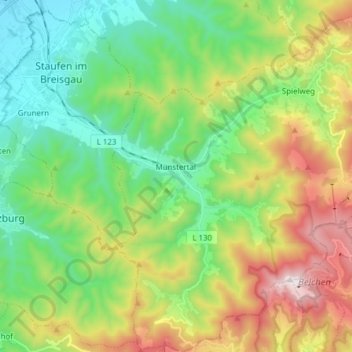
Name: Münstertal topographic map, elevation, terrain.
Average elevation: 643 m
Minimum elevation: 245 m
Maximum elevation: 1,407 m
Make a donation
Other topographic maps
Click on a map to view its topography, its elevation and its terrain.
Dietenbach
Germany > Baden-Württemberg > Landkreis Breisgau-Hochschwarzwald > Kirchzarten (Kernort) > Kirchzarten
Average elevation: 482 m
Rheintal
Germany > Baden-Württemberg > Landkreis Breisgau-Hochschwarzwald > Müllheim im Markgräflerland
Average elevation: 424 m
Wolfenweiler
Germany > Baden-Württemberg > Landkreis Breisgau-Hochschwarzwald
Average elevation: 261 m
Make a donation