
Thank you for supporting this site ❤️
Make a donation
Make a donation
Great Barton topographic map
Click on the map to display elevation.
Thank you for supporting this site ❤️
Make a donation
Make a donation
About this map
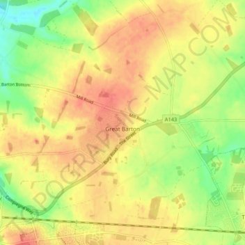
Name: Great Barton topographic map, elevation, terrain.
Location: Great Barton, West Suffolk, Suffolk, England, United Kingdom (52.24988 0.72519 52.29450 0.80625)
Average elevation: 54 m
Minimum elevation: 24 m
Maximum elevation: 74 m
Thank you for supporting this site ❤️
Make a donation
Make a donation