Geolocate

Moldoveanu topographic map

Interactive map

Click on the map to display elevation.

About this map

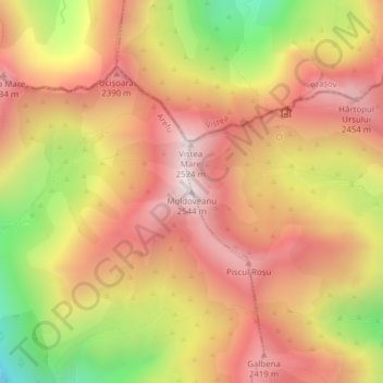
Name: Moldoveanu topographic map, elevation, terrain.

Location: Moldoveanu, Argeș, Romania (45.59944 24.73604 45.59954 24.73614)

Average elevation: 2,140 m

Minimum elevation: 1,570 m

Maximum elevation: 2,520 m

Other topographic maps

Click on a map to view its topography, its elevation and its terrain.

Constanța

Romania > Constanța

Constanța, Constanta Metropolitan Area, Constanța, Romania

Average elevation: 19 m

Maia

Romania > Maia

Maia, Mureș, 547392, Romania

Average elevation: 439 m

Mureș

Romania > Mureș

Mureș, Romania

Average elevation: 554 m

Sălaj

Romania

Toplița, Sălaj, 457223, Romania

Average elevation: 292 m

Câineni

Romania > Râmnicu Vâlcea

Câineni, Râmnicu Vâlcea, Vâlcea, Romania

Average elevation: 1,001 m

Argeș

Romania

Arefu, Argeș, 117041, Romania

Average elevation: 825 m

Danube Delta Biosphere Reserve

Romania > Tulcea

Danube Delta Biosphere Reserve, Tulcea, 827051, Romania

Average elevation: 3 m

Buru

Romania > Buru

Buru, Cluj, 407318, Romania

Average elevation: 554 m

Argeș

Romania

Mățău, Argeș, 117484, Romania

Average elevation: 826 m